

An impressive range of transportation and infrastructure projects currently planned and/or underway in New York City are promising to transform the passenger experience and the quality of public spaces in the city. Transportation and infrastructure projects are among those most uniquely positioned to partner with and provide spaces through Transit Oriented Development (TOD) and other synergistic relationships.
These projects impact the ways we live and move in the city, so it is critical that they tie seamlessly into the public realm as they present incredible opportunities to make civic-oriented spaces better than those that previously existed.
In recent years, we’ve experienced the creation of very successful public pedestrian-focused spaces in those that were once car-based: Times Square, and 33rd Street between Seventh and Eighth avenues. We now see the opportunity to build on this positive trend.
New Yorkers enjoy and share our public spaces, so it is essential that architects lead the way in making well-designed, environmentally sound connections between these newly planned and constructed infrastructure projects and the existing streetscapes. In addition to working with the associated city agencies, we have the opportunity to partner with developers as they introduce valuable housing and associated TODs.
Among the many capital improvement transportation and infrastructure projects that have the potential to deliver on those promises are:
In addition to the project’s potential to provide a direct connection between a range of diverse neighborhoods in Brooklyn and Queens, easing the travel for thousands, each station location presents a unique opportunity for improvement and new public spaces. How the new stations intersect with the existing streetscape and the communities they serve will be crucial to their success. Each new station (there will be 19 in all) will serve as a direct link between community and transit.

As a key component of the Bus Terminal Replacement project, the Port Authority of NY & NJ is planning to create approximately 3.5 acres of new, publicly accessible open space. This new green space will be developed on “deck-overs”—platforms built over the currently below-grade Dyer Avenue, cut once the new main bus terminal is constructed. This public space aims to enhance the commuter and community experience by adding a significant area of green space to the neighborhood.

The federal government’s recent takeover of the project may point to its moving forward. While its future is unknown, most proposals for the development include significant public spaces, perhaps building on the recent improvements—the aforementioned and wildly successful 33rd Street plaza and the new entrances on Seventh Avenue.

The four new Metro-North stations that will service the East Bronx are excellent examples of well-designed, properly integrated urban spaces. The areas directly surrounding the stations have been thoughtfully designed with pedestrian plazas that link the station seamlessly to the city streetscapes. Environmentally sound principles are in play, with drought-resistant landscaping and water-retention drainage.

NYC is funding a $400 million “Future of Fifth” project to transform a stretch of Fifth Avenue between Bryant Park and Central Park into a pedestrian-friendly boulevard. Construction is set to begin in 2028, with the project including widened sidewalks, more green space with planters, and fewer vehicle lanes to encourage walking and boost local businesses. The plan aims to create a world-class walkable street and “a world-class network of public space in Midtown,” which will increase the area’s value as a destination that spurs economic growth. To this end, the proposal recommends “making Fifth Avenue from Bryant Park to Central Park a vibrant corridor for pedestrians by expanding sidewalks, improving lighting, and adding more seating.”

The city’s ongoing trend for dedicated busways presents an untapped opportunity to reenvision the entire public right-of-way along the routes into world-class transit corridors that also support pedestrians and green public spaces.
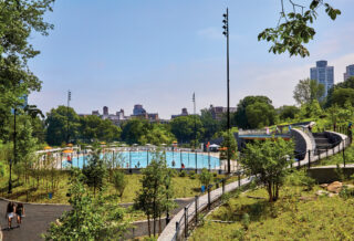
In August, the city unveiled the “Greater Greenways; the New York City Greenway Plan” for the expansion of the growing network of greenways across New York City. The plan will connect greenways—continuous, multiuse corridors designed for human-powered and electric-assist transportation and recreation—to parks and other green public spaces along the routes. The Greenway program is divided into two chapters, the Greenways of Today and the Greenways of Tomorrow, and aims to increase public access to parks and waterfront.
In many cases, some of the most people-friendly projects are still perceived only as “nice-to-haves.” No doubt, as these projects progress and time and budgets become stretched, some elements could be compromised. As architects with a keen eye on the public realm, we have the responsibility to monitor these projects and ensure that the preservation and development of these spaces that belong to New Yorkers are vital and exciting—and that they continue to play a large role in making the city we love so special.

THOMAS GRASSI, FAIA, cochair; RUSSELL KRIEGEL, AIA, co-chair; and EVE MICHEL, AIA, director of programming, (“Moving in the Right Direction”) are members of the AIA New York Transportation and Infrastructure Committee. The mission of the committee is to examine the architecture of transportation and infrastructure projects, and to advocate
for design quality in these projects.