


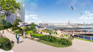

Lower Manhattan is the birthplace of New York City, and over the centuries the neighborhood has continued to evolve as part of a transforming and growing city. Today, it remains an iconic global symbol of our city and an exemplar of dynamism and resilience. By the 2040s, however, tidal flooding and more frequent and severe coastal storms will threaten the long-term viability of the Financial District and Seaport neighborhoods. Over the last two years, an interdisciplinary team of planners, engineers, architects, and landscape architects worked in close collaboration with NYCEDC and MOCEJ to develop a strategy for adapting the one-mile stretch of shoreline from the Brooklyn Bridge to The Battery. Released in December 2021, the Financial District and Seaport Climate Resilience Master Plan is a shared Citycommunity vision for a resilient 21st-century waterfront. It illustrates an approach that embraces this once-in-a-generation opportunity to create a vision for transforming the waterfront to better serve all New Yorkers for generations to come. Grounded in community and regulatory input, climate science, engineering, and feasibility analysis, the master plan reflects an ambitious vision that can be realized. The primary design challenge is to achieve these resilience goals while ensuring functionality of, and access to, the waterfront. Lower Manhattan’s waterfront is a unique confluence of urban life and infrastructure where our vast network of subways, ferries, and highways converge and connect. This waterfront houses maritime facilities that serve the entire region, mooring space for chartered vessels and historic ships, and the Downtown Manhattan Heliport. It is a constellation of public open spaces, amenities, and historic landmarks that links together a dense and diverse urban space. Below grade lies a network of critical, dense underground infrastructure including five subway lines, critical power transmission lines, and the sewer interceptor. Above, the superstructure of the elevated FDR viaduct complicates the siting of any shoreline improvement. This dense urban fabric leaves limited space to site flood defense without walling off the community. To achieve the project’s objectives requires a bold approach: extending the shoreline of Lower Manhattan into the East River to create space for flood defense infrastructure and waterfront uses. The proposed design envisions a new multi-level public waterfront. The upper level will protect against coastal storms, with buried floodwalls that create elevated open spaces with expansive views of the harbor and the city. A lower-level esplanade will be close to the water itself and connect to piers and ferries. Ferry terminals will be redeveloped into new resilient and modern facilities with room for future expansion. This waterfront will also be designed to help advance the City’s sustainability goals. The master plan identifies opportunities to integrate renewable energy as part of any new buildings or structures along the water. Nature-based solutions will be woven throughout to help manage stormwater, provide shade, and reduce local summer temperatures. Finally, this new shoreline edge will incorporate opportunities for ecological enhancements, providing new habitats for fish and other aquatic organisms.