


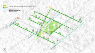
As cities reflect on the impacts of the COVID-19 pandemic, it is critical to carry forward lessons learned into future public space planning. The Flatiron & NoMad District Plan is a holistic strategy for 110 acres of central Manhattan, developed in response to pandemic-related disruptions. During this period, pedestrian activity declined by approximately 80%, while transit and vehicular traffic dropped by 30–50%, according to NYC Department of Transportation data. In collaboration with NYC DOT, the Flatiron NoMad Business Improvement District, and local stakeholders, the plan aimed to restore foot traffic, support local businesses, and create safer, more flexible public spaces. Public engagement—including surveys and virtual workshops—highlighted the need not only to activate outdoor areas, but also to better connect them through pedestrian-focused, park-like corridors. To inform this approach, the team analyzed anonymous mobility data and conducted on-site observations to identify underutilized streets and spaces with potential for expanded walking, biking, and gathering. A comprehensive GIS analysis of land use, transit access, and street conditions supported an evidence-based strategy. The result was the “Community Park Network,” which reimagines streets as connectors between parks, plazas, and transit, prioritizing people over vehicles. Analysis showed that nearly 6.5 acres of roadway—roughly the size of Madison Square Park—were underused during the pandemic. The plan proposed reallocating this space through a phased approach, integrating initiatives such as Open Streets and Broadway Vision. By transforming streets into vibrant public spaces, the plan demonstrates a lasting model for more resilient, people-centered urban design.